
Road
Road adds no terrain speed ceiling. Car Drive Groups currently use 70 mph forward and 20 mph reverse; other group types use their configured speed.
Live read-only Central London colours · HxAR 2.0
Explore the complete fixed Central London canvas now: move around, zoom in and inspect its HexTile geometry. A shared London base pattern gives the canvas its roads, water, buildings and places; sparse choices saved to HxAR’s Production database override individual tiles. All 22 active colours can appear here. The colours work now; the behaviour attached to some types may change as HxAR develops.
Where is the Pixel Map?
You can test the fixed 214,016-HexTile canvas on this page without installing another app build. Its geometry, pan, zoom, selection, keyboard controls, responsiveness and current Production colours can be checked now.
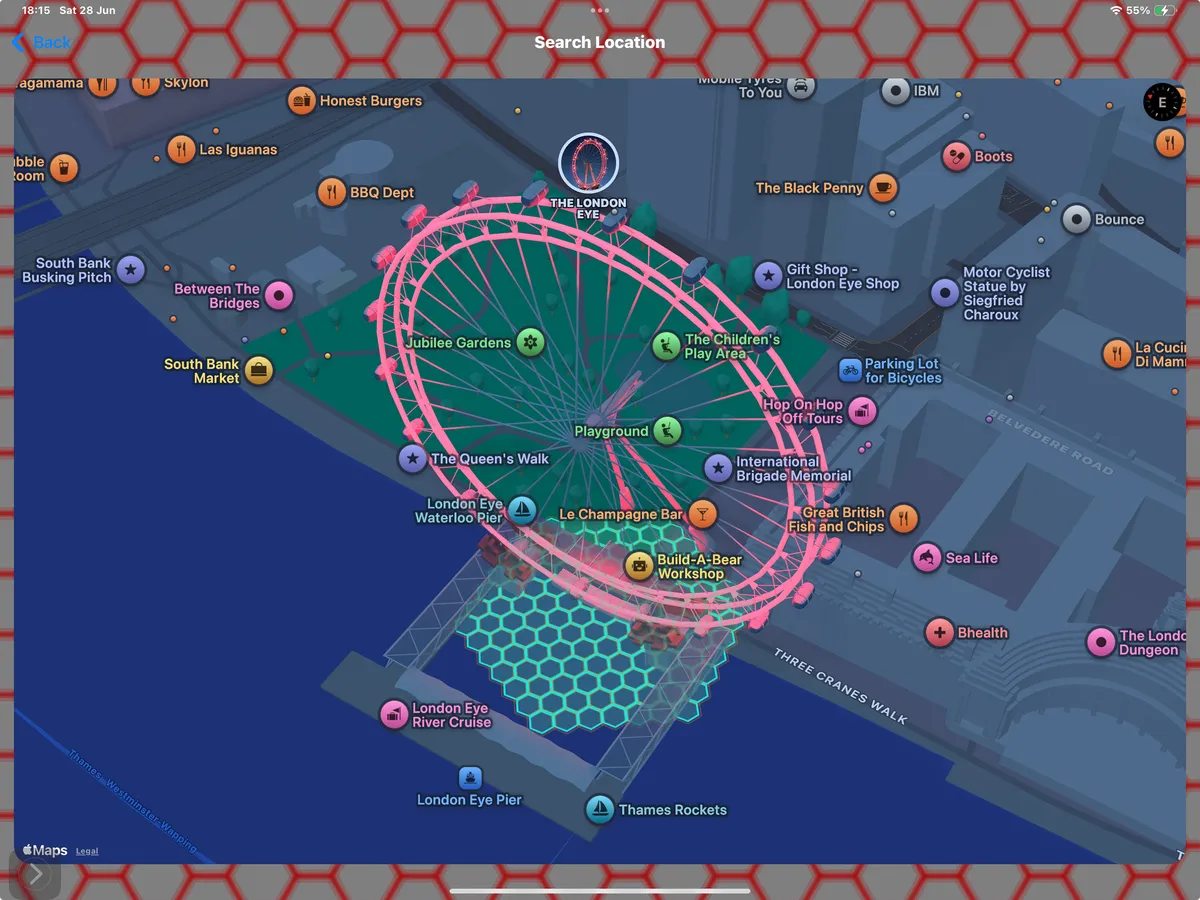
The website is a viewer, not a drawing tool. Permitted changes are made only in the HxAR app through Search Location → HxAR Metaverse → tap a HexTile → HexTile Options. HxAR saves the chosen type to its Production CloudKit HexTile record using terrain or plannedTileType. A protected, read-only Production feed supplies only sparse colour overrides and canvas positions required to layer those choices over the shared London base. HxAR Metaverse remains its own renderer beside Standard, Satellite and Mapbox map views.
The canvas starts with a versioned Central London pattern, then layers active HexTile choices saved to HxAR’s Production database only—not Development—and checks using the schedule saved on this device. The website never changes, assigns or purchases a tile.
Production colour feed: Loading live colours · Last Production update: Waiting for first update · Website tile writes: none
Drag to pan, pinch or use the controls to zoom, and tap a cell to inspect it. With a keyboard, use the arrows to move, +/− to zoom, 0 to fit and Enter or Space to hear the selected state.
A HexTile can only be changed through HxAR. This website does not paint, save, assign, buy or protect tiles, and it makes no tile write requests.
No location permission is requested. This schematic virtual canvas is not a surveyed boundary, basemap, navigation map, physical ownership, access right or permission to enter a place.
Loading the Central London base map and Production overrides.
From app choice to read-only mosaic
Choose a colour in HxAR, then return here to see the safe visual state on the read-only Central London canvas. No identity, address, ownership or location-history details are published.
Use Search Location, open HxAR Metaverse and tap a HexTile. Search Location calculates the surrounding virtual grid when it is needed; the usual six-ring view contains 127 tiles.
Open HexTile Options, then choose a colour/type. HxAR saves it to the Production CloudKit HexTile record using terrain or plannedTileType.
The HxAR Metaverse renderer shows the chosen type as a full-colour HexTile with a recognisable pattern. The colour works now; the behaviour attached to additional types can evolve as HxAR develops.
The Central London viewer lets you pan, zoom and inspect all 214,016 HexTiles across 352 staggered rows × 608 cells. It combines the shared London base pattern with sparse colour overrides from HxAR’s Production database only—not Development; only the app can change a HexTile.
Gameplay underneath the colour
An additional active colour changes the visible style without replacing the base terrain beneath it. Its attached behaviour may evolve.
Road adds no terrain speed ceiling. Car Drive Groups currently use 70 mph forward and 20 mph reverse; other group types use their configured speed.
Grass keeps off-road driving to 10 mph.
A grounded avatar or vehicle submerges, then returns to the last recorded non-water coordinate or a visible non-water tile when available.
Property Land supports virtual ownership, connected properties and VR buildings.
Road uses true black #000000, replacing the previous near-black charcoal. On this page, a cyan edge keeps the swatch visible against the dark background. In HxAR, tile outlines are separate from the terrain fill and can vary with ownership.
Twenty-two verified app styles
The additional tile types use both a named colour and a recognisable in-app pattern, so meaning does not depend on colour alone. All 22 colours are selectable in HxAR and visible here now; their attached behaviour can evolve.
Why come back?
Return to see how app-made colour choices have changed a line, district or symbol linked to a real area.
The website remains a viewer. Changes are made in HxAR, where an unowned tile remains changeable even after assignment and active virtual ownership protects its choices for the owner.
A Railway, Stadium or HxArcade colour can be visible now while the behaviour associated with that type continues to develop.
Any signed-in user can change an unowned tile’s terrain or additional colour type. Assignment does not protect it. Active virtual ownership protects those choices so only the owner can manage them.
Ways to use the palette
These examples describe patterns users can create in HxAR with today’s colours and view here. A visible colour does not promise that every activity associated with its label is final.
The shared base already traces mapped roads, green spaces, water and bridges. An explicit choice made in HxAR can replace any one of those base colours, and the read-only website displays the Production override.
App users can place pink Arts Venue, indigo Cinema, purple Event Space, orange Shop and off-white Public Plaza colour types beside one another.
App users can combine cyan HxArcade, yellow Beach, cedar-brown Wooden Hexagon House and lime Football Stadium tiles while their associated behaviour continues to evolve. HxArcade uses controller-and-arcade markings, while Wooden Hexagon House uses timber-house markings, so neither plan is identified by colour alone.
Start with one real area
The expanded Central London map contract defines an approximately 4 km × 2 km canvas around the same centre. It contains 214,016 HexTiles arranged as 352 staggered rows × 608 cells. The familiar existing map remains centred inside it, providing four times the current geographic coverage.
At 100%, the live read-only viewer shows the familiar existing Central London area. At 25% · Full map, it shows the complete expanded map. Every position starts with the shared London base pattern; a sparse Production override replaces that base colour only where an app user has made an explicit choice. Starting with one measurable area keeps privacy, performance and colour mapping testable before considering another city.
A small pilot on a very large grid
The worldwide figures describe theoretical capacity, not a database containing trillions of existing tiles.
Tiles are calculated as required. They are not all created or stored in advance.
Real places require real care
Pixel Maps must remain a visual layer—not an instruction to travel, enter land or treat a virtual choice as a physical fact. Never use HxAR while driving.
A virtual HexTile never grants physical access. It is an in-app location cell—not a surveyed boundary, land title, tenancy, access right or permission to enter a physical location.
Read AR safety guidanceNearby maps and AR depend on location access. The public Production Pixel Maps feed exposes only sparse visual overrides needed for the mosaic—not personal identity or private location history.
Read the privacy noticePublic patterns must follow the community rules, with a clear route for reporting abusive or inappropriate content.
Report contentAny HexTile purchase is a virtual in-app entitlement. An active Shop colour type does not promise physical-goods checkout, which would remain subject to Apple’s rules and applicable law.
Purchases and refundsClear answers
Yes. You can pan, zoom and inspect the complete fixed Central London canvas as a read-only website map. It displays the shared London base pattern plus sparse visual overrides supplied from HxAR’s Production database.
No. The website is a read-only viewer. Signed-in users make permitted HexTile colour choices in the HxAR app; the website does not paint, save or submit changes.
Yes. The protected read-only Production feed carries explicit colour overrides to the Central London canvas. Use Refresh map if you want to check immediately rather than wait for its automatic refresh.
No. HxAR Metaverse remains one of four in-app map views. Pixel Maps is a separate website visualisation that reflects selected HexTile colours.
The shared base pattern is derived from mapped OpenStreetMap features, but it remains a schematic HxAR layer—not a survey or navigation map. A later Road, Bridge, Shop or other Production override is an explicit virtual HxAR choice and does not claim that the physical feature exists there.
Starting with one fixed area keeps the first map measurable and stable. The expanded Central London pilot covers approximately 4 km × 2 km with 214,016 HexTiles—four times the current geographic coverage; other areas could be designed later.
They describe visible geographic area. At 100%, the viewer shows the familiar existing Central London area. At 25% · Full map, it shows the complete expanded map: twice the width and twice the height, covering four times the area.
Explore the map with HxAR 2.1
Pixel Maps reads Production HexTile colours only—not Development. HxAR 2.1 is now available on the App Store with improved HexTile maps. Viewing this website map never changes a HexTile.