
How To Topic 06 · GEO AR Radar
How to Find Nearby Virtual Properties and Stories with HxAR Radar
Radar helps you discover location-linked virtual HexTiles and Shared Stories around you. The dashboard control and the full-screen radar use different tap-and-hold gestures, so this guide explains both before you start.
What this guide achieves
Open GEO AR safely, understand the red and green states, choose a useful detection radius, read nearby virtual-property results and open an assigned Shared Story.
- Topic
- 06
- Starting point
- Circular GEO AR radar at the upper right of the signed-in HxAR dashboard
- Guide time
- About 10 minutes
- Screen status
- Development feature guide
Quick walkthrough
Use HxAR Radar in eight steps.
Stop somewhere safe, choose the correct dashboard gesture, turn on the full radar, review its virtual results and switch tracking off when you finish.
- 01
Stop somewhere safe and check location access
Stand still, hold the device securely and make sure HxAR has the foreground location access you intend to grant. Never read Radar while driving or crossing a road.
- 02
Choose the dashboard gesture
Tap the small dashboard radar to open full GEO AR. Press and hold that dashboard radar for about 0.55 seconds only when you want to switch its nearby tracking on or off without opening the full view.
- 03
Tap the large radar to start tracking
The full GEO AR screen deliberately opens switched off. Tap its large circular radar to request live location and heading updates; tap it again to stop them.
- 04
Press and hold the large radar to set the range
A press and hold inside full GEO AR opens Radar Settings instead of switching tracking. Choose a detection radius from 1 to 50 metres.
- 05
Read the rings, markers and property cards
Use the radar as a virtual-property guide. Markers can appear across the larger visual range, while cards below it show fetched HexTiles inside the smaller detection radius, nearest first.
- 06
Check a Shared Story before opening it
A dashboard Story nearby prompt lets you choose Not Now or Open. Full GEO AR can also open the closest assigned story automatically after tracking is on and it is found within your detection radius.
- 07
Allow the story to finish loading
Open can lead through an iCloud lookup, an asset download and a device-scene check before Story AR appears. Review any additional confirmation instead of assuming the scene will open immediately.
- 08
Turn Radar off when you finish
Tap the large radar until it is red before leaving full GEO AR. If you return to the dashboard while it is still green, press and hold the small radar to stop its live updates.
The dashboard radar and full Radar use different gestures
The small circular control at the upper right of the camera dashboard is a shortcut and a tracking switch. A normal tap opens full GEO AR. A press and hold of approximately 0.55 seconds switches the dashboard’s nearby location and heading tracking on or off.
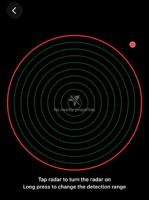
Inside full GEO AR, the gestures change: tap the large radar to start or stop tracking, and press and hold it to open Radar Settings. Full GEO AR starts red and switched off deliberately, even if you opened it by tapping the dashboard control.
Green means HxAR has requested live location and heading updates. It does not prove that permission is available, the GPS fix is fresh or the reported position is precise. Red means live updates have been stopped, although previously fetched results can remain visible.
The current development view does not always stop the shared Radar automatically when you leave full GEO AR. Turn it red before going back; if it remains green on the dashboard, press and hold the small radar to stop it.
Choose a 1–50 metre detection radius
Press and hold the large full-screen radar to open its half-height settings panel. The Detection Radius slider runs from 1 to 50 metres in one-metre steps and starts at 10 metres after a fresh app launch.
The larger visual Radar Range is always ten times the selected detection radius: 10 to 500 metres, with a 100-metre default. Ten rings are drawn, so each ring represents approximately one selected detection-radius step.
The detection radius controls when fetched property cards and assigned stories become eligible. The larger visual range controls where fetched markers can be plotted; increasing it does not guarantee that more CloudKit records will be returned.
Smaller range
Useful when nearby markers overlap or you want story prompts only at close range. Indoor GPS drift can still move an estimated result across the boundary.
Larger range
Shows a wider plotting area and allows cards or stories to become eligible farther away, subject to the development query and the location currently available.
Distance is an estimate
Radar measures a straight line to a virtual HexTile centre. It is not road distance, journey time, a surveyed property boundary or a navigation instruction.
Read markers and nearby virtual-property cards
Full Radar plots fetched HexTiles inside the larger visual range. A blue dot means the tile has no sponsorship reference. A cyan AR-shaped marker means a sponsorship reference exists; it does not prove that a sponsor is currently accepted, verified or endorsed by HxAR.
Cards beneath the radar are a narrower list: they include fetched tiles inside the selected detection radius and are sorted nearest first. A card can show a map thumbnail, location, owner or accepted sponsor, sponsorship state and Open Story when an assigned story is available.
Each row represents an individual virtual HexTile, not one unique postal property. Neighbouring virtual tiles can receive the same street-address label, so the same displayed location can appear more than once. Check each row rather than assuming the database has duplicated one tile.
The small dashboard radar is only a preview. It plots the first eight results it receives, not necessarily the nearest eight, and can clamp a distant marker to the outer edge.
From a Story nearby alert to Story AR
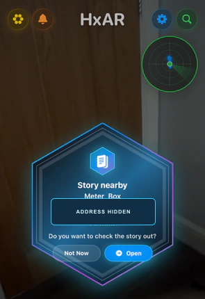
While dashboard Radar is active, HxAR can show the closest fetched assigned story inside your detection radius. The prompt contains its title, a location label, an estimated straight-line distance and two choices.
Choose Not Now to dismiss that detection. The same prompt can return after you leave and re-enter the range or Radar is reset. Choose Open to stop the current dashboard GPS updates, clear its nearby results and begin Shared Story lookup.
Full GEO AR behaves differently: after tracking is on, it can automatically open the closest assigned story found within the detection radius, without showing the dashboard’s Not Now or Open prompt first. A nearby property card can also provide a manual Open Story button.
The automatic and manual full-GEO story routes do not stop live Radar tracking in the current development build. When you finish the story, return to Radar and turn it red. This differs from the dashboard prompt’s Open action, which stops its GPS updates before starting lookup.
Opening a story can require an iCloud or saved-copy lookup, downloading missing public-gallery assets, checking the scene weight against the device and a further Open Story confirmation. The property context card can remain visible over Story AR.
No nearby properties is not always a final result
The development screen displays No nearby properties whenever its list of fetched results is empty. That can mean Radar is off, a location is unavailable, permission was declined, the network or CloudKit request failed, or the current request returned no records.
The current fetch turns the available location into a short area code called a six-character geohash and sends it to HxAR’s public CloudKit database. It checks only that area, not neighbouring geohash areas, and does not yet ask CloudKit for additional result pages. Results can therefore be incomplete near an area boundary or at a larger range.
A failed request has no separate on-screen error and can leave older results in memory. If the result seems wrong, check the red or green state, location permission and connection, move to an open safe position for a better GPS fix, then switch Radar off and on once.
Understand the location and privacy boundary
While tracking is enabled, Radar requests best-accuracy device location and heading. It uses that position to estimate distance and derives a geohash prefix for the public CloudKit query, so Radar should not be described as wholly on-device, anonymous or a feature where no location-derived data leaves the device.
The current Radar code writes precise virtual HexTile-centre coordinates, some tile or story identifiers and distance information to diagnostic logs. Those logs and the query design need release review, clear purpose and retention controls before stronger privacy claims are made.
If Nearby Collectables is enabled in Settings, the same verified foreground location update can also enter its discovery process. Review that optional setting separately. Switching Radar off does not revoke Apple location permission; change the permission later in iOS Settings → Apps → HxAR.
The screenshots on this private preview use opaque blue privacy masks over every visible address. A public Story, property card or profile can still reveal information its creator chose to publish, so avoid including a home address or another person’s personal information.
Radar finds virtual content, not physical hazards
Radar does not detect people, traffic, walls, steps, moving objects or unsafe ground. Stop walking before reading a card or opening Story AR, never use it while driving, and pause if the camera view becomes distracting or uncomfortable.
A virtual HexTile, owner label or sponsor label provides no physical land ownership, access right, invitation to enter, safety assurance or endorsement. Respect private property, restrictions and local conditions.
Indoor GPS can drift substantially. A label such as 7 metres away is an estimate to a virtual coordinate, not proof that a physical object is seven metres away.
Accessibility status of this development preview
The dashboard and full Radar have overall VoiceOver labels, but VoiceOver does not offer a separate action for either press and hold. Range settings are available only by holding the large radar. Individual tiny markers do not announce their count, distance or direction.
Some owner and sponsor names respond to touch but are not identified to VoiceOver as buttons. Several result, Sponsor, Open Story, Not Now and Open controls are below Apple’s general 44-point default touch-target recommendation, and the fixed prompt and half-height settings panel still need Larger Text and localisation testing.
The radar rotates with device heading, which can rotate its No nearby properties text. Its sweep and sponsor pulse can repeat without checking Reduce Motion. HxAR 2.0 remains under accessibility review; colour alone, a responsive layout or one overall label should not be treated as proof that the feature is fully accessible.
Shared Stories and public profiles are user-created content. The reviewed Radar flow does not yet provide the complete in-app filtering, reporting and blocking controls expected for user-generated-content services. Use the report-content route below while those app-side controls are addressed.
Guide path
Move through HxAR one topic at a time.
New topics will be linked back into earlier guides whenever one action leads naturally to another.
Helpful now