
How To Topic 07 · Maps & HexTiles
How to Use Maps, Search Locations and HexTiles in HxAR
HxAR places a virtual HexTile layer over real-world coordinates. In HxAR 2.1, World View lets you explore the 3D Earth and enter the HxAR Metaverse at a chosen location. Map Search and Tracker View remain available for finding places and inspecting the local HexTile grid.
What this guide achieves
Find a real-world location, select the correct virtual HexTile and choose the right action without confusing assignment, shared content or virtual ownership.
- Topic
- 07
- Starting point
- Signed-in HxAR dashboard with the Map shortcut visible
- Guide time
- About 11 minutes
- Screen status
- HxAR 2.1 release guide
Quick walkthrough
Find, assign and use a HexTile in nine steps.
Choose how HxAR should centre the map, inspect the local grid, then decide whether you need a private assignment, owner-controlled shared content or renewable virtual ownership.
- 01
Open Map from the dashboard
Rotate the outer dashboard dial until Map is visible, let the dial settle, then tap Map.
- 02
Choose World View, Map Search or Tracker View
Choose World View to explore the 3D Earth and enter the HxAR Metaverse. Choose Map Search to enter a place or coordinates, or Tracker View to centre on a current-location fix.
- 03
Find the location
In World View, rotate, search or zoom towards a place, then zoom close and release. When the location is ready, tap Enter the HxAR Metaverse. In Map Search, enter an address or valid latitude and longitude. In Tracker View, allow location access and wait for a position fix.
- 04
Reveal and inspect the HexTiles
Show the local HexTile layer, move the map until the intended position is clear, then tap the rendered hexagon you want to inspect.
- 05
Open the tile actions
Use Details or Options for the selected tile. Read its location, category, ownership and other available information before continuing.
- 06
Assign the tile to My Properties
Assigning saves the tile to your own property-management area. It is a personal organisation action and does not make you its owner.
- 07
Choose the correct kind of content
Use My Experience for private notes and photos held on this device. Only an active owner can attach or change the shared Story and other owner-controlled tile details.
- 08
Buy only when virtual ownership helps
An eligible assigned tile can be bought when it is still unowned and you have enough Hexagon Tokens. The result is renewable one-year in-app ownership, not physical land ownership.
- 09
Use the best Property Visit map style
During a Property Visit, compare Standard, Satellite, Mapbox 3D and HxAR Metaverse views while keeping provider attribution visible.
Open Map from the rotating dashboard dial
Map is one of the destinations on the bronze outer dial. Rotate the dial until Map is visible, allow it to settle, then tap the shortcut. The HXAR MAPS chooser offers World View, Map Search and Tracker View.
This guide begins on the signed-in dashboard. If the Map shortcut is not currently visible, keep rotating the outer ring rather than tapping an empty numbered position on the smaller inner dial.
Enter the HxAR Metaverse through World View
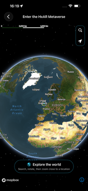
Select World View, labelled Explore the 3D Earth, to open the globe. Rotate Earth to browse, pinch to zoom, or use the search control to find an address or coordinates. The location arrow can centre the globe on your device’s location when permission is available.
The initial prompt says Explore the world: Search, rotate, then zoom close to a location. Zoom into the place you want and lift your fingers. HxAR prepares the local area and shows an Enter the HxAR Metaverse button when it is ready. Tap that button to continue into the virtual world.
Searching or zooming helps you choose a place; the entrance button is the final step. The dedicated World View guide below explains each control and how to return to the globe.
Choose worldwide Map Search or current-location Tracker View
Map Search is the manual route. Enter a place or address, or use coordinates with latitude from −90 to 90 and longitude from −180 to 180. HxAR centres the generated HexTile grid on the result, so you can explore land or sea without being physically present there.
Tracker View is the current-location route. It requests Apple’s When In Use location permission, obtains a position and heading, and then stops its location updates shortly afterwards to conserve power. Treat it as a current-location fix, not a promise of continuous journey tracking.
Manual Map Search does not need your live GPS position, but an address lookup still uses Apple mapping and geocoding services. If you do not want to search an address, valid coordinates provide the more direct route.
Understand the HexTile grid around the location
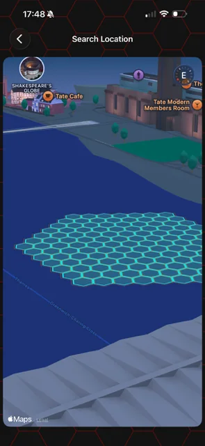
The normal Search Location view calculates an active grid of 127 virtual HexTiles: one centre tile and six surrounding rings. Tap TILES when that control is available to reveal the grid, then use the map and compass to orient the patch before selecting a tile.
HxAR can calculate a HexTile for real-world coordinates worldwide. The implementation divides the globe into 288 geographic sections. At the current 3.8-metre centre-to-corner HexTile radius, that represents approximately 13.6 trillion potential positions in theory. It does not create or store all of them in advance: tiles are calculated when needed, and persistent information is saved only where the app needs it.
The hexagons are HxAR’s virtual coordinate layer. Their outlines are not surveyed boundaries, cadastral records or a reliable guide to where a physical property begins or ends.
Select one HexTile and review its actions
Tap a rendered hexagon to select it, then open Details or Options. Read the available location, tile type, owner and property information before making a change. A map label identifies a nearby real-world place; it does not prove that the whole labelled place fits inside one HexTile.
If an unowned tile offers Change Tile Type, HxAR checks ownership again when you save. That second check matters because another person may have completed an ownership purchase after you first opened the options.
Remote searching means you do not have to stand on the physical location to inspect a virtual tile. It also means a tile action is never permission to visit, enter or use the real place.
Assignment and ownership are different
Assigning a HexTile adds it to your own Property Management records. You can organise it with a private label, folders and a favourite state, and you can return to your saved My Experience. Assignment is useful for research, planning and quick access.
You can assign a tile even when another HxAR user owns it. Your private label does not rename the owner’s property, and assignment does not stop somebody else buying an unowned tile.
Only active virtual ownership prevents another user from buying that same virtual HexTile. It does not prevent other people from viewing, visiting or privately assigning the tile.
Choose private My Experience or an owner-controlled shared Story
My Experience is the private route for an assigned tile. Use it for your own notes and photos about the location. In the current development build, that material is stored on the device and is not added to the shared property record or CloudKit.
A shared Story is different. Only the active HexTile owner can attach or change the Story AR assets and shared Story details for that tile. While a tile is unowned, any signed-in user can currently change its allowed terrain or additional active colour type; active ownership protects those choices so only the owner can manage them.
Choose the private route when the material is only for you. Choose an owner-controlled Story when you have the required ownership and intend other people to discover a shared AR experience. Do not publish personal information, private-home details or content you do not have permission to share.
Buy renewable virtual ownership only when you need it
Before a purchase can proceed, you must be signed in, the tile must be assigned to you, HxAR must verify that it is still unowned and your Hx Vault must contain enough Hexagon Tokens. Development-preview costs vary by tile category rather than using one universal price.
A successful purchase creates renewable one-year in-app HexTile ownership. Return while signed in before its expiry to renew it free in the current development design. If the entitlement expires, the tile can become available to another eligible user.
Virtual ownership can support an owner-controlled Story, terrain choice, additional colour type and connected virtual-property strategy. It is not a purchase of land, title, tenancy, access, planning consent or any other real-world right.
Compare the four Property Visit map styles
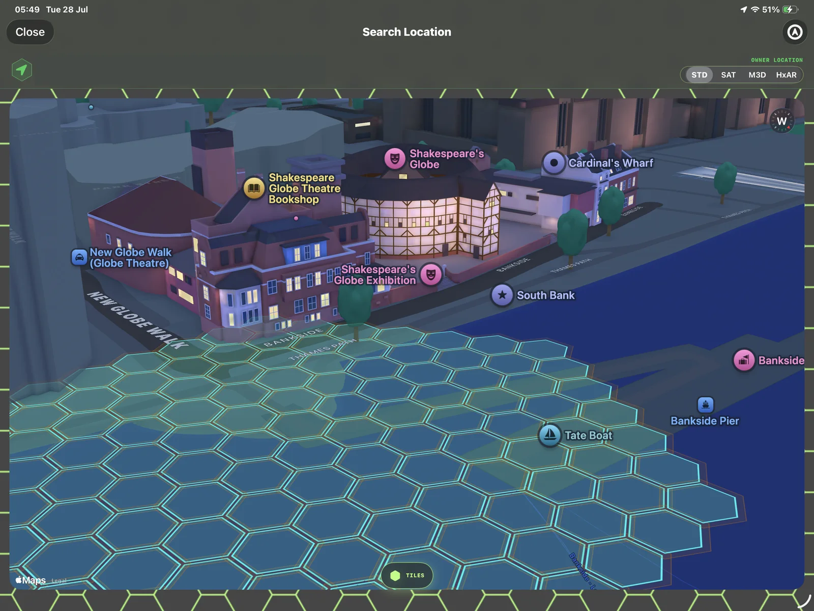
During a Property Visit, the style selector can show STD, SAT, M3D and HxAR. STD is Apple’s standard map, SAT is Apple’s satellite presentation, M3D is the Mapbox 3D presentation, and HxAR opens the app’s own HxAR Metaverse geographic view.
Start with the view that makes the location easiest to understand. Standard is useful for a familiar map, Satellite adds aerial context, Mapbox 3D helps show building form, and HxAR Metaverse presents HxAR’s virtual geographic world. The best choice depends on the task rather than one style being universally more accurate.
Keep Apple Maps, Mapbox and other provider attribution visible whenever their map content is shown or reproduced.
Plan a business or gameplay use without overpromising
An actively owned HexTile can become part of a digital venue, a location-linked Story trail, a game area or a business experience. HxAR can also group from 2 to 100 edge-connected tiles when the requester actively owns every tile in the group.
Begin with the experience people should discover, then choose only the tiles needed to support it. Check whether the intended tiles touch edge to edge before planning a connected group, and keep a clear distinction between the colour visible now and behaviour that may still evolve.
Owning or grouping virtual tiles does not guarantee an audience, revenue, exclusivity in the physical place or approval from a landowner or authority. Any real-world promotion, event, access or commercial activity still needs the ordinary permissions and legal checks.
Protect location privacy and solve common map problems
Tracker View uses When In Use location. Assigning a tile saves identifiers and geographic information to HxAR’s CloudKit records, while a completed ownership record also includes the virtual tile centre and resolved location information. My Experience notes and photos are the separate on-device-only route in the current development build.
If Map Search cannot find a place, check the spelling or try valid coordinates. If Tracker View cannot centre correctly, confirm location permission, move somewhere with a clearer position fix and try again. If a purchase action is unavailable, confirm that the tile is assigned, still unowned and that your Hx Vault has enough Hexagon Tokens.
Stop before reading controls while walking, never use HxAR while driving and remain aware of traffic, steps, water, other people and restricted locations. A virtual map result is not a travel instruction or a safety assessment.
The large map screenshot on this private preview uses an opaque privacy mask over its demonstration address and coordinates. Public landmark labels and required map-provider attribution remain visible.
Guide path
Move through HxAR one topic at a time.
New topics will be linked back into earlier guides whenever one action leads naturally to another.
Helpful now