
How To Topic 35 · HexTile editing
How to Update HexTiles with the HxAR Options Cube
HxAR 2.1 brings individual HexTile actions into a rotating HxAR Options cube. Turn the cube to find the tile’s current type, Height, Services and other available actions while keeping the virtual world in view. This guide explains how to make a deliberate terrain update and verify what was saved.
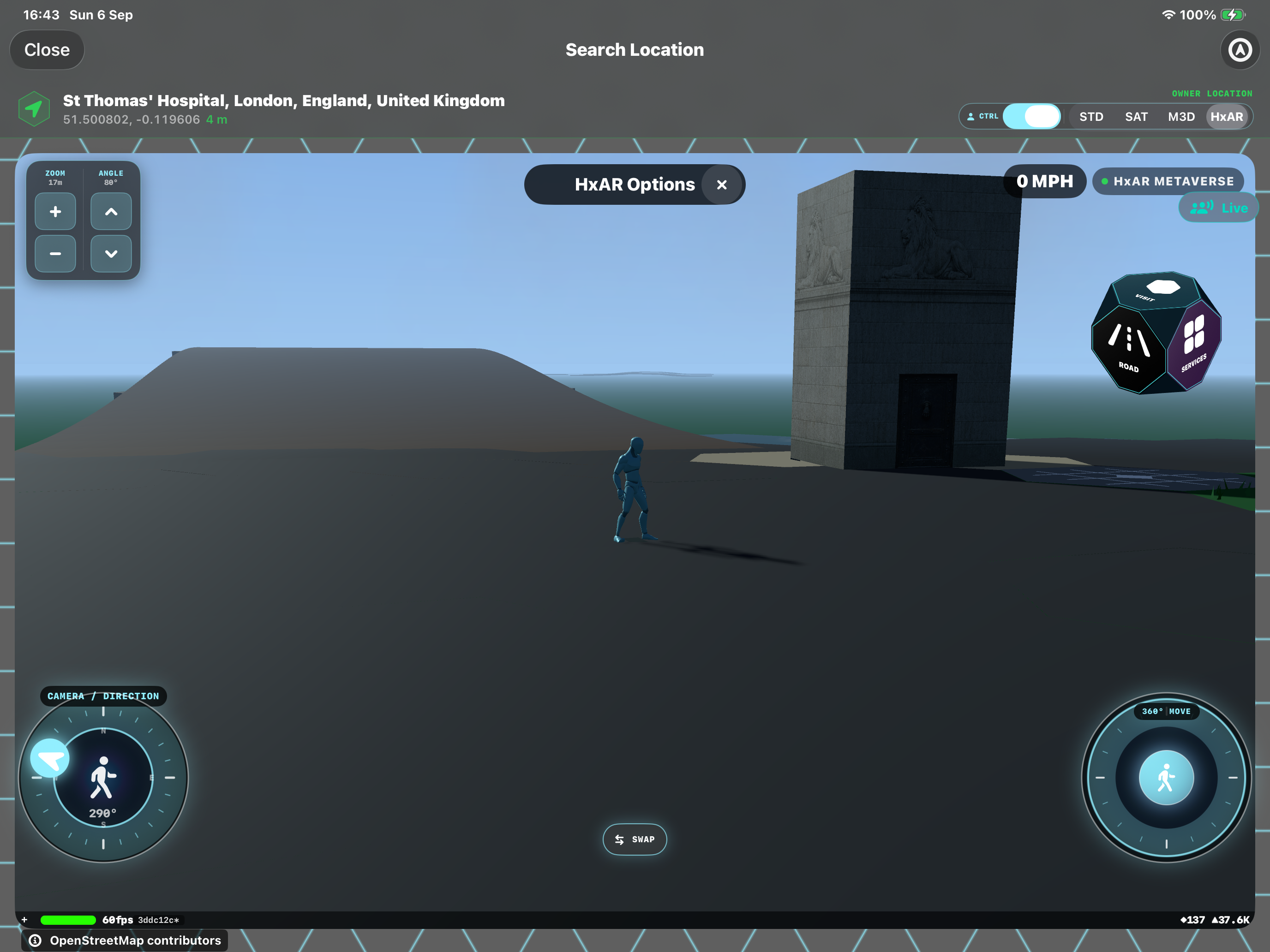
What this guide achieves
Select an editable individual HexTile, use the options cube and distinguish immediate type saves from the height editor’s explicit Save action.
- Topic
- 35
- Starting point
- Signed in, viewing an unowned individual HexTile or your own actively owned individual HexTile in HxAR Metaverse
- Guide time
- About 10 minutes
- Screen status
- HxAR 2.1 release guide
Quick walkthrough
Update an individual HexTile in seven steps.
Use a single tile with visible ground for your first edit. Grouped properties, buildings and services can open different controls.
- 01
Open the HxAR view and stop moving
Enter a local world through World View or Visit Location and select HxAR. Pause, frame the land with ZOOM and ANGLE, and choose an individual tile you can identify.
- 02
Tap the tile’s visible ground
Tap an unowned individual HexTile while signed in, or a tile you actively own. HxAR Options opens when editing is available. Buildings, shops, grouped properties and other owners’ tiles can open different flows.
- 03
Rotate the options cube
Drag the cube horizontally or vertically. Release, then tap a labelled face. One face shows the current type, such as Road in the screenshot. Rotating the cube does not change the terrain.
- 04
Inspect the HexTile type choices
Tap the current type face to open HexTile type. Scroll through the available choices. Use an information button to read about a type before selecting it; close that view with Done.
- 05
Select a type and wait for its save
Tap the intended new type. Selection starts saving immediately, without a separate Save button. Wait, check any message and inspect the land. HexTile Type Wasn’t Saved means the change has not been confirmed.
- 06
Adjust eligible land height separately
Return to the cube and tap Height. If allowed, use the plus and minus controls in HEXTILE HEIGHT, choose Curve or Level, then tap Save. If unavailable, read the reason instead of repeatedly tapping. A height edit is not saved merely by changing its displayed number.
- 07
Verify and close the controls
Reopen Height to check its Saved value, or inspect the type face after a terrain change. Close a type or service panel to return to the cube. Closing Height returns to the world; tap the tile again to reopen its options. X beside HxAR Options closes the options.
Know what each cube face opens
Drag the cube to reveal faces; tap to activate them. Service shortcuts appear when applicable. VoiceOver users can choose available faces through the cube’s Actions menu.
Current type
The face uses the current terrain or additional type’s name, icon and colour. Tap it to open HexTile type and choose a different permitted option.
Height
Opens the compact height editor for eligible land, or explains why that tile cannot be adjusted.
Services
Shows applicable actions such as Sign Post, Shop and Advert Board. A tile without manageable services displays an explanation; choosing a terrain does not automatically set up every service.
Visit, Ownership and Info
Visit opens the selected tile’s property view. Ownership explains who can manage it. Info explains the current tile and its type. Add asset has its own selection panel for asset actions.
Unowned tiles are shared; owned tiles are protected
Any signed-in user can change a permitted type on an unowned HexTile, including an unowned tile somebody has assigned to their account. Assignment alone does not reserve the terrain choice. Another signed-in user may change that shared tile later.
Active virtual ownership restricts terrain management to the owner. Another player’s ordinary tile normally opens its visitor flow. Special administrator moderation controls do not give ordinary visitors editing rights over somebody else’s land.
Ownership is checked when changes are saved, so an open menu does not guarantee that permission still applies. The cube’s free-claim action is administrator-only; ordinary users should not expect every unowned tile to offer a free purchase.
Choose the terrain before adding a type such as Public Plaza
Base terrain includes Road, Grass, Water, Property Land, Sea, River, Lake, Forest, Snow and Rock, subject to the choices currently permitted. It controls the underlying movement, water and building behaviour. Additional types include Public Plaza, Shop and Railway and can supply their own appearance and related features.
An additional type keeps the underlying terrain. For example, a styled tile can still have water beneath it. Choosing a base terrain clears the additional type, including when you choose the base terrain that was already underneath it. Read the label and information rather than relying on the rendered colour alone.
Selecting a type saves immediately. Opening an information button or rotating the cube does not save anything. The colour reference guide provides the wider palette and Pixel Maps background; this guide covers the updated 2.1 editing controls.
Raise eligible land with Curve or Level
The height panel keeps the selected land visible beside it. The current controls adjust the offset in 50 mm steps, from 0 to 3,000 mm above the natural reference. Minus reduces a raised offset; it does not excavate below zero.
Curve keeps the land’s natural shape and shifts it upward. Level makes a flat surface based on the tile’s natural centre, with the chosen offset added. A zero offset with Level can therefore differ from untouched natural ground.
Tap Save to apply the draft. A confirmed save closes the panel; reopen it to see the saved measurement. The curved-arrow reset control returns the tile to natural height and shape. Reset is itself a saved change, and its successful result leaves the panel open showing Natural.
Height is unavailable on water, tiles welded into a Big Property, Bridge-type tiles and land with a dependent structure. The app also blocks a height record this version cannot interpret. Read the reason displayed for the selected tile. These limits can differ from whether you are allowed to change its type.
If the expected options or changes do not appear
If a door, product or building opens instead, close it and tap visible ground on the intended individual tile. Land View is for footprint inspection and can follow a different selection flow; return to the normal HxAR view for these tile options.
A greyed cube or temporarily disabled close control can mean a save is still running. Wait for it to finish. For a failed type or height save, read the message, check connectivity and reopen the tile before retrying so you can confirm its current ownership and saved state.
Closing a height draft without Save leaves the saved height unchanged. Closing the type panel after selecting a new type does not undo the save that selection already started. If you want to reverse a confirmed type change, select the previous type again while you still have permission.
Guide path
Move through HxAR one topic at a time.
New topics will be linked back into earlier guides whenever one action leads naturally to another.
Helpful now